
Promoted Route Updates
From time to time there will be diversions or temporary closures of some sections of the walking and cycling routes promoted in the National Landscape
Any changes or updates will be posted on this page, as well as being shared on our social media channels.
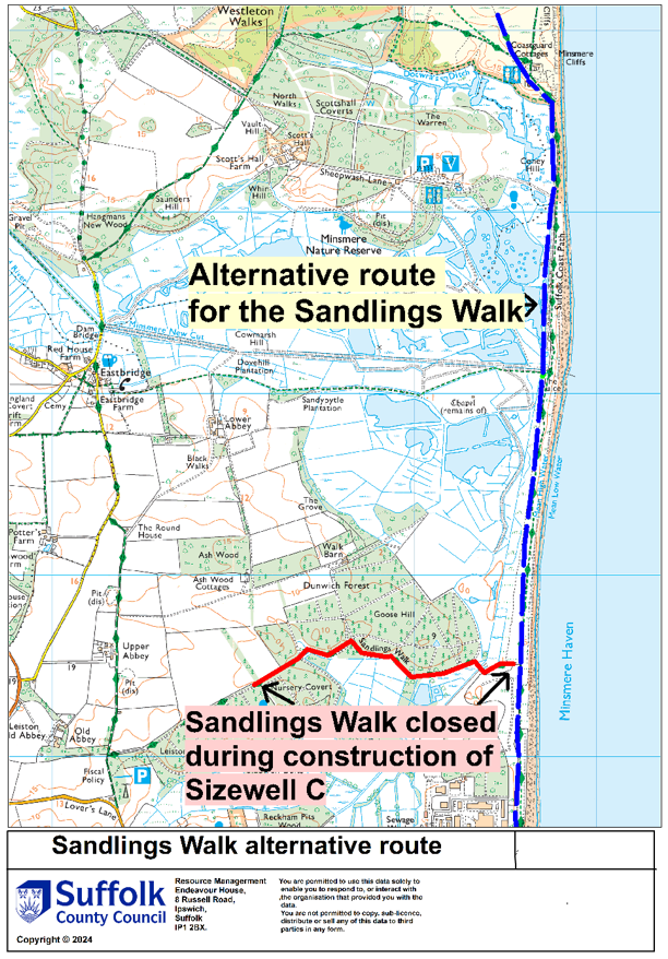
Sandlings Walk
16th January 2025 Update
A planned closure will affect the Sandlings Walk whilst Anglia Water carry out essential works directly adjacent to the public right of way. The map shows the closure and suggested alternative route. It is intended that the closure will operate from 03/02/2025 - 14/02/2025.
1st January 2025 Update
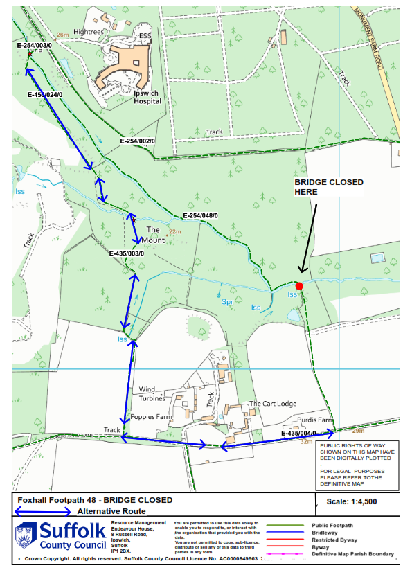
Sandlings Walk closed at Brookhill Wood, Foxhall, Ipswich (Foxhall Footpath 048 (part) – At Footbridge). In the interests of public safety, the Footpath is closed due to a severely damaged footbridge.
Alternative route: Purdis Farm Footpath 4 – Purdis Farm Footpath 1 – Purdis Farm Footpath 3 – Rushmere St Andrew Footpath 24 – Foxhall Footpath 3 and vice versa. The following map shows the diversion:
22nd February 2024 update
The Suffolk Coast Path
2018 Update - Stage 2 - The Suffolk Coast Path was a few years ago moved further inland from the former Southwold – Reydon - B1127 – Covehithe Broad – Covehithe route. The current route is shown in the Official Guide (published by Cicerone) and goes further inland to Frostenden Corner before heading back to the coast at Covehithe.
When heading N out of Southwold – Follow the green lane running inland from Easton Marshes to the B1127. When you reach the B1127 turn ‘S’ along the road and take the first ‘R’ Covert Road joining Rissemere Lane East. Head N on Rights of Way near Reydon Grove Farm to Frostenden Corner. Take the lane heading E to South Cove, then head N on B1127 and take the 1st R which is the lane to Covehithe.
When heading S out of Covehithe – Take road heading ‘W’ from Covehithe to B1127 (via Crossways Cottages). When you reach the B1127 turn ‘S’ along the road And take 1st R opposite South Cove Church. Follow road to Frostenden Corner. Leave road and head S on Rights of Way to join Rissemere Lane East near Reydon Grove Farm. Head E on Rissemere Lane East To join Covert Road heading S. At ‘Y’ junction turn ‘L’ onto B1127. Take green lane that leads from E side of B1127 to coast just N of Southwold Pier.
The Stour and Orwell Walk
When walking between Stutton Ness and Stutton Mill (and vice versa) your route follows the beach/foreshore (passable in all but high tides and bad weather).
DO NOT use a route above the shore as the area is subject to cliff falls and landslips. Walk along the river beach/foreshore, steering well clear of the base of the cliffs. However, please check the tides and ensure that you have enough time to walk the 2km/1.25 miles well before any high tide comes in.
Please also read, understand and follow our Cliff Safety Guidance.